 |
| |||||||||||||||||||||||||||||||||||||||||||||
Tue Jun 18 15:37:41 IST
Trains
| ♥♥All Imaginary Trains♥♥ | ||
| New Trains | To Be Introduced | |
| Special | Pending | |
| Festival **new | Special Fare **new | |
| Bedroll/Linen **new | LHB Rakes **new | |
| Vande Bharat | Amrit Bharat | |
| Humsafar | Antyodaya | |
| Tejas | Uday | |
| Rajdhani | Shatabdi | |
| Duronto | Garib Rath | |
| Sampark Kranti | Jan Shatabdi | |
| Suvidha | Premium Tatkal | |
| AC Express | AC SuperFast | |
| Mail/Express | SuperFast | |
| Passenger | Toy | |
| MEMU/DEMU | Double Decker | |
| Delhi EMU | Hyderabad | |
| Chennai EMU | Kolkata EMU | |
| Mumbai EMU | Pune EMU | |
ΣChains
| All ΣChains |
Atlas
| Main |
| Delhi Metro |
PNR
| Main |
| PNR #Follows |
| Recent Refreshes |
| Recent Refresh Requests |
| Blank PNRs |
| New PNRs |
| Recent Predictions |
| Recent Stampings |
| Surprises |
| Past Un-Stamped |
| Today's PNRs |
| Today's Un-Stamped |
| Tomorrow's PNRs |
| Tomorrow's Un-Stamped |
Forum
| Main | #Follows |
| Travel Tips | |
| Timeline | Travelogues |
| Polls | Popular |
| UnAnswered | Archived |
| Imaginary Train Blogs | Race Blogs |
Quiz
| Main Quiz Feed |
Gallery
| All Pics |
| All Station Pics |
| All Train Pics |
| All Loco Pics |
News
| Main |
| Major Accidents/Disruptions |
| New/Special Trains |
| Official Press Releases |
| Crime |
| Rail Budget |
| Trains in the News |
| Stations in the News |
Trips
| All Trips |
| Today's Departures |
| Post PNR | Post Blog | Advanced Search |
Please wait...
Blog Entry# 1487019
Posted: May 27 2015 (10:35)
No Responses Yet
No Responses Yet
May 27 2015 (10:35) DNGI/Dangari (1 PFs)
Biplob Kagyung
Biplob Kagyung 0 blog postsEntry# 1487019 Tags Past Edits
May 29 2015 (3:37PM)
Station Tag: Dangari/DNGI added by জয়দীপ JOYDEEP जय़दीप*^/90119
May 29 2015 (3:37PM)
Station Tag: Tangni/TNGNI removed by জয়দীপ JOYDEEP जय़दीप*^/90119
May 29 2015 (3:36PM)
Station Tag: Tangni/TNGNI added by জয়দীপ JOYDEEP जय़दीप*^/90119
May 29 2015 (3:35PM)
Station Tag: Tangni/TNGNI added by জয়দীপ JOYDEEP जय़दीप*^/90119
May 29 2015 (3:34PM)
Station Tag: Murkeongselek/MZS removed by জয়দীপ JOYDEEP जय़दीप*^/90119
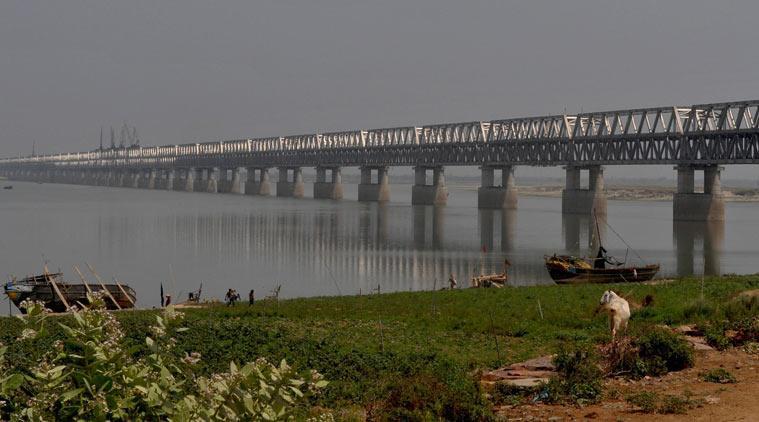
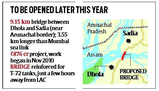
Longest bridge in India provides a quick link to LAC Line of Actual Control
--------------------------------------------------------------------------------------------------------
The scope of the work includes construction of the 9.15 km bridge and 16.65 km of approach roads at a cost of Rs 876 crore.
--------------------------------------------------------------------------------------------------------
At...
more...
--------------------------------------------------------------------------------------------------------
The scope of the work includes construction of the 9.15 km bridge and 16.65 km of approach roads at a cost of Rs 876 crore.
--------------------------------------------------------------------------------------------------------
At...
more...
9.15 kilometres, the country’s longest bridge, between Dhola and Sadia in Assam, is slated for commissioning later this year, about five years after construction commenced on the Rs 876 crore strategic project that would drastically improve road connectivity to the border state of Arunachal Pradesh.
Road connectivity is crucial, as the state does not have a single operational airport along its 3488-km border with China. It just has an operational heliport near Itanagar. China, on the other hand, has vastly improved roads and is building or extending air strips on its side of the Line of Actual Control (LAC).
“Currently, armed forces have to enter Arunachal Pradesh via Tezpur (about 186 km from Guwahati) in Assam. There is no bridge fortified for passage of tanks around Tinsukia from where troops can cross over to Arunachal Pradesh. It takes about two days from Tezpur to reach the border in Dibang and Anjaw,” says Akash Borah, a resident of Tinsukia and deputy manager, Navayuga Dhola Infra Projects Limited, which is executing the bridge project over the Brahmaputra.
The bridge is 3.55 km longer than the sea link over the Mahim Bay in Mumbai — the longest bridge in the country so far. “Strategically this bridge is of great importance as it will significantly improve connectivity from Assam to Arunachal Pradesh,” said a senior official in the Ministry of Road, Transport and Highways.
At present, Tinsukia (about 350 km east of Tezpur), on the eastern edge of Assam, is the closest access point to cross over to Lohit, and then to Anjaw district in Arunachal Pradesh. Buses and trucks ply from Tinsukhia via Parashuram Kund in Arunachal Pradesh (a distance of about 152 km) and then 45 km onward to Teju. The road is circuitous and poorly developed. The other option is to ferry across the river but that too is difficult as the Brahmaputra keeps changing its course.
“The Dhola-Sadia bridge has been reinforced for the passage of T-72 tanks. Once the bridge is commissioned, it will take 30 minutes to cross over to Sadia, which is near the Lohit border. The travel time will be cut by up to four hours,” said Prashanta Bhattacharya, team leader, S N Bhobe & Associates — the independent engineer for the project. From there, it will take only a few hours to reach the LAC.
The Army has a cantonment at Walong, about 180 km from the district headquarters of Tezu in Lohit. A little ahead, the strategically important town of Kibithu (in Anjaw district) is located, with China to the north and Myanmar to the east China has a sizeable deployment of troops opposite Kibithu Tatu, Tithang and at Rongtu Chu valley west of Tithang.
There have been repeated incursions by Chinese troops in the fish-tail area — called so because of the unique shape of the LAC there — in Anjaw district of Arunachal Pradesh. In August 2013, China’s People’s Liberation Army (PLA) reportedly crossed the LAC and occupied territory 20 km around Chaglagam in Anjaw district for nearly four days. PLA soldiers make no efforts to remove evidence of their intrusions as China doesn’t recognise Arunachal Pradesh as Indian territory.
Senior government officials said while the process of raising a mountain strike corps has begun, India lacks infrastructure on its side of the LAC as compared to China. “Our troops have to be moved by air to advanced landing grounds and then walk several miles to the border posts. They are supplied by mule trains. The government has now taken a decision to strengthen the border road network,” said an official who did not wish to be identified.
While the construction work on the bridge started in November 2010, the letter of appointment was handed over in June 2011. The scope of the work includes construction of the 9.15 km bridge and 16.65 km of approach roads at a cost of Rs 876 crore. Of this, Rs 592 crore is being provided by the government.
please wait...Translate to English
please wait...Translate to Hindi
Travel SAFE
1. RailFanning does NOT MEAN dangerous pics/videos.
2. Doorplating pics/youtube videos are strictly FORBIDDEN in IRI.
3. Take plenty of food pics and other safe pics.
4. Write human interest narratives to make the pics interesting.
5. Enjoy blogging and travelling SAFELY.
REMEMBER: YOUR LIFE is the most precious thing, NOT RailFanning.
Leading Polls
| 6093175 ★★★ 37 | jishnuthakur12301^... |
| 4317553 ★★★ 270 | AvishekRay~ |
| 5085167 ★★★ 213 | jishnuthakur12301^... |
Top Trending Posts
| 6097199 ★ 7 | arishabh1819~ |
| 6098771 ★ 7 | _V_K_^~ |
| 2067657 ★★ 12 | Rfchannel121~ |
| 6009357 ★★★ 131 | Mridul^~ |
| 6098007 ★ 6 | Lone_Ranger~ |
| 6098832 ★★ 13 | IWANTTOBERLYMINIST... |
| 6084960 ★★ 20 | vgirik69 |
| 6087924 ★ 8 | Train.ka.diwana~ |
| 6098600 ★★ 13 | jishnuthakur12301^... |
| 6098575 ★ 8 | Exynos9611~ |
| 6098063 ★★ 16 | VedantKumar_Bihars... |
| 6096476 ★★★ 43 | VIVEKEXPRESS^~ |
| 6098102 ★ 10 | MeghaSyam^~ |
| 823349 ★★ 14 | JayarajCharan~ |
| 6074749 ★★ 15 | Vijayawada^ |
| 6098568 ★ 8 | Exynos9611~ |
| 6094804 ★★★ 49 | Sakthivel~ |
| 6055967 ★★★ 57 | Arnab_K~ |
| 6098176 ★★★ 44 | Harsha_12627^~ |
| 6093831 ★★ 20 | Exynos9611~ |
| 6098527 ★ 6 | Rail12345 |
| 6097791 ★★★ 28 | Arnab_K~ |
| 6098474 ★ 8 | _V_K_^~ |
| 5962198 ★★★ 50 | way_thelong^~ |
| 6091753 ★★★ 24 | PankajMishra^~ |
| 6095835 ★★ 16 | PremrajPadiyachi~ |
| 6093175 ★★ 21 | jishnuthakur12301^... |
Rail News
- Patalpani Kalakund Heritage Train: मानसून के शबाब पर आने के साथ ही शुरू होगी हेरिटेज ट्रेन
News Entry# 556628
by: Adittyaa Sharma Today (12:18)
गर्मी और उमस से परेशान इंदौरवासियों को अब मानसून की झमाझम बारिश का इंतजार है। बारिश के साथ ही शहर के नजदीक पर्यटन स्थल फिर गुलजार हो जाएंगे। इसके साथ ही पातालपानी-कालाकुंड हेरिटेज ट्रेन भी शुरू हो जाएगी। पर्यटक इसके विस्टाडोम कोच में बैठकर खूबसूरत प्राकृतिक नजारों को निहार सकेंगे।
HighLights... - राजधानी और न्यू जलपाईगुड़ी-उदयपुर सिटी का बदला रूट
News Entry# 556627
by: Adittyaa Sharma Today (12:15)
कटिहार मंडल के रंगापाणी स्टेशन व चटेर हाल्ट के बीच सियालदह जा रही 13174 कंचनजंघा एक्सप्रेस और मालगाड़ी के मध्य टक्कर बाद रेलवे ने कई ट्रेनों का मार्ग...
मुजफ्फरपुर,... - कंचनजंघा हादसा: शताब्दी एक्सप्रेस समेत 4 ट्रेनें रद्द, आज भी कई ट्रेनों का रूट बदला
News Entry# 556626
by: Adittyaa Sharma Today (12:14)
पश्चिम बंगाल में न्यू जलपाईगुड़ी के पास सोमवार को हुए कंचनजंघा एक्सप्रेस हादसे के बाद मंगलवार को भी शताब्दी और इंटरसिटी एक्सप्रेस समेत चार ट्रेनें रद्द की गई हैं।
पश्चिम... - रेलवे स्टेशन के पास मिले शव का नहीं हुआ शिनाख्त
News Entry# 556625
by: Adittyaa Sharma Today (12:02)
गिरिडीह, प्रतिनिधि। गिरिडीह रेलवे स्टेशन के गेट नंबर दो के निकट एकाडेमी के पीछे गली में मिले अज्ञात व्यक्ति के शव का शिनाख्त नहीं हो सकता...
गिरिडीह,... - ट्रेन से गिरकर यात्री घायल
News Entry# 556624
by: Adittyaa Sharma Today (11:59)
देवघर, प्रतिनिधि।जसीडीह रेलवे स्टेशन पर सोमवार शाम ट्रेन से गिरकर एक यात्री घायल हो गया। मामले की जानकारी आरपीएफ को होते ही इलाज के लिए सदर...
देवघर,...
New Trains
- Type: ExpNDLS/New Delhi to RJPB/Rajendra Nagar Terminal (Patna)
Run Date: ONLY ON Jun 18
Runs: Tue
Dep: 17:15 Arr: 07:00 +1
Updated: Today (11:27) - Type: ExpMAU/Mau Junction to JU/Jodhpur
Run Dates: Jun 17 to Jul 01
Runs: Mon
Dep: 04:00 Arr: 08:55 +1
Updated: Today (06:41) - Type: ExpRMD/Ramanathapuram to TBM/Tambaram
Run Dates: Jun 22 to Jul 29
Runs: Mon,Sat
Dep: 15:00 Arr: 03:15 +1
Updated: Yesterday (20:38) - Type: ExpDNR/Danapur to BHET/Bhestan
Run Dates: Jun 16 to Jul 15
Runs: Sun,Mon,Thu
Dep: 11:00 Arr: 23:30 +1
Updated: Today (12:38) - Type: SFJBP/Jabalpur to CBE/Coimbatore Junction
Will Run till: Dec 27
Runs: Fri
Dep: 23:50 Arr: 17:10 +2
Updated: Yesterday (16:33) - Type: ExpSIR/Sirhind Junction to SHC/Saharsa Junction
Run Dates: Jun 19 to Jun 26
Runs: Wed
Dep: 02:00 Arr: 09:45 +1
Updated: Yesterday (13:12) - Type: ExpSHC/Saharsa Junction to SIR/Sirhind Junction
Run Dates: Jun 17 to Jun 24
Runs: Mon
Dep: 19:30 Arr: 00:05 +2
Updated: Yesterday (12:58) - Type: ExpASR/Amritsar Junction to DBG/Darbhanga Junction
Run Dates: Jun 19 to Jun 26
Runs: Wed
Dep: 04:25 Arr: 11:00 +1
Updated: Yesterday (12:55) - Type: ExpDBG/Darbhanga Junction to ASR/Amritsar Junction
Run Dates: Jun 17 to Jun 24
Runs: Mon
Dep: 20:20 Arr: 01:25 +2
Updated: Yesterday (12:55) - Type: ExpPNBE/Patna Junction to NDLS/New Delhi
Run Date: ONLY ON Jun 17
Runs: Mon
Dep: 21:30 Arr: 15:00 +1
Updated: Yesterday (10:15)
Site Announcements
- Entry# 5648027
Mar 01 2023 (12:44AM)
In response to past confusions with Train/Station updates and resulting fights and controversies, the following clear and objective guidelines are being issued, with no room for any arguments or debates about validity. Also, included, some other changes with respect to Ratings. 1. All Red Ratings will require further explanation. Red Ratings won't... - Entry# 5388512
Jun 24 2022 (08:45AM)
As announced previously, there are a few changes coming to IRI user accounts, based on past practices. 1. As before, you will be able to quickly DELETE your IRI User account at ANY time. However, the menu option for this was hidden in the profile page, and could not easily be located.... - Entry# 5148000
Nov 29 2021 (06:40AM)
A new feature will be released soon, whereby you can follow blogs tagged with specific Trains & Stations. If you have already posted blogs tagged with some Train/Station, then you will be set to automatically follow that Train/Station. Thereafter, any future news/blogs tagged with those Trains/Stations will be marked to your... - Entry# 5093784
Oct 13 2021 (07:04AM)
These days, every other day, we are getting requests from members to allow email login to their FB-based IRI account. 10 years ago, we had given the option for users to login through FaceBook - in retrospect, this was a mistake. These days, apparently, users are quitting FaceBook in droves because... - Entry# 4906979
Mar 14 2021 (01:12AM)
Followup to: Fmt Changes The new version of FmT 2.0 will soon be here - in about 2 weeks. As detailed in the previous announcement, many of the old FmT features like Train TT, Speedometer, Geo Location, etc. will be REMOVED. It will be a bare-bones simple app, focused on trip blogging. It... - Entry# 4898771
Mar 06 2021 (10:33PM)
There are some changes coming to FMT. Many of the features of FMT, like station arrival, TT, speed, geo, passing times, station time, etc. are ALREADY available in OTHER railway apps. So all of these features will be REMOVED. We'll have ONLY BLOGGING - quick upload of pics/videos/audio, etc. You may attach...
Member Blog Links
Scroll to Top