 |
| |||||||||||||||||||||||||||||||||||||||||||||
Thu May 2 12:36:39 IST
Trains
| ♥♥All Imaginary Trains♥♥ | ||
| New Trains | To Be Introduced | |
| Special | Pending | |
| Festival **new | Special Fare **new | |
| Bedroll/Linen **new | LHB Rakes **new | |
| Vande Bharat | Amrit Bharat | |
| Humsafar | Antyodaya | |
| Tejas | Uday | |
| Rajdhani | Shatabdi | |
| Duronto | Garib Rath | |
| Sampark Kranti | Jan Shatabdi | |
| Suvidha | Premium Tatkal | |
| AC Express | AC SuperFast | |
| Mail/Express | SuperFast | |
| Passenger | Toy | |
| MEMU/DEMU | Double Decker | |
| Delhi EMU | Hyderabad | |
| Chennai EMU | Kolkata EMU | |
| Mumbai EMU | Pune EMU | |
ΣChains
| All ΣChains |
Atlas
| Main |
| Delhi Metro |
PNR
| Main |
| PNR #Follows |
| Recent Refreshes |
| Recent Refresh Requests |
| Blank PNRs |
| New PNRs |
| Recent Predictions |
| Recent Stampings |
| Surprises |
| Past Un-Stamped |
| Today's PNRs |
| Today's Un-Stamped |
| Tomorrow's PNRs |
| Tomorrow's Un-Stamped |
Forum
| Main | #Follows |
| Travel Tips | |
| Timeline | Travelogues |
| Polls | Popular |
| UnAnswered | Archived |
| Imaginary Train Blogs | Race Blogs |
Quiz
| Main Quiz Feed |
Gallery
| All Pics |
| All Station Pics |
| All Train Pics |
| All Loco Pics |
News
| Main |
| Major Accidents/Disruptions |
| New/Special Trains |
| Official Press Releases |
| Crime |
| Rail Budget |
| Trains in the News |
| Stations in the News |
Trips
| All Trips |
| Today's Departures |
Mar 30 2018 (12:16)
SaurabhDubey^~
SaurabhDubey^~ 30243 blog postsEntry# 3251848 Past Edits
Mar 30 2018 (12:27)
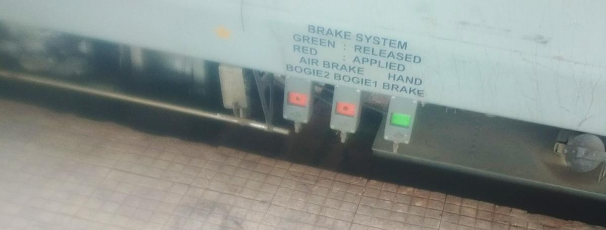
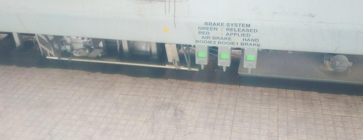
Where is the Brake system indicator in Lhb rake:
Mar 30 2018 (12:26)
Braking system indicator in the lhb rakes are located just besides diesel filling point of the EOG
This system works even when EOG is switeched off and hog mode is activated
Where is the Brake system indicator in Lhb rake:
Mar 30 2018 (12:26)
Braking system indicator in the lhb rakes are located just besides diesel filling point of the EOG
This system works even when EOG is switeched off and hog mode is activated
Where is the Brake system indicator in Lhb rake:
Braking system indicator in the lhb rakes are located just besides diesel filling point of the EOG.
Green stands for released
Red stands for applied.
While...
more...
Braking system indicator in the lhb rakes are located just besides diesel filling point of the EOG.
Green stands for released
Red stands for applied.
While...
more...
first two lights are for air brake
Third one is for hand brake.
This system works even when EOG is switeched off and hog mode is activated.
Third one is for hand brake.
This system works even when EOG is switeched off and hog mode is activated.
please wait...Translate to English
please wait...Translate to Hindi
Lhb rake mein Brake system indicator kahan hai:
Braking system indicator lhb rakes mein diesel filling point ke paas hota hai.
Green release ko darshata hai.
Red applied ko darshata hai.
Pehle do lights air brake ke liye hoti hain.
Teesri light hand brake ke liye hoti hai.
Ye system EOG band hone par bhi aur hog mode active hone par bhi kaam karta hai.
#Faq can it be added to faq #monitors
please wait...Translate to English
please wait...Translate to Hindi
Types of Railway Construction Surveys
Once a decision has been taken during preliminary investigations about the general feasibility and desirability of a railway line, surveys are undertaken before the construction of the new line. The following types of surveys are normally conducted:
(a) Traffic survey
...
more...
Once a decision has been taken during preliminary investigations about the general feasibility and desirability of a railway line, surveys are undertaken before the construction of the new line. The following types of surveys are normally conducted:
(a) Traffic survey
...
more...
(b) Reconnaissance survey
(c) Preliminary survey
(d) Final location survey
The details of these surveys are discussed in the following sections.
1 Traffic Survey
Traffic survey includes a detailed study of the traffic conditions in the area with a view to determine the
(a) most promising route for the railway in the area,
(b) possible traffic the railway line will carry, and
(c) standard of railway line to be followed.
Traffic surveys are normally undertaken in conjunction with reconnaissance or preliminary engineering surveys so that the technical feasibility and relative costs of alternative proposals can be formulated. The traffic survey team should work in close cooperation with the engineering survey team. The survey team should visit all trade centres in the area and consult local bodies, state governments, and prominent citizens regarding trade and industry and propose the most suitable alignment for the new line.
Traffic survey consists of an economic study of the area keeping in mind the following considerations, information on which should be collected in detail:
(a) Human resources
(b) Agricultural and mineral resources
(c) Pattern of trade and commerce
(d) Industries located and projected
(e) Prospects of tourist traffic
(f) Existing transport facilities
(g) Locations of important government and private offices
(h) Planning for economic development of the area
The traffic survey team should make an assessment of the traffic likely to be carried by to the new line. While carrying out the survey, details of traffic likely to be offered by various government organizations, public bodies, or private enterprises should be gathered.
At the end of the survey, a report should be formulated by the officer-in-charge of the survey. The formation of the report is governed largely by the nature of the terms of reference and the investigations made. The traffic survey report should normally contain the following information:
(a) History of the proposal and terms of reference
(b) General description
(c) Potentials and prospects
(d) Industrial and economic development and traffic projections
(e) Population projection and volume of passenger traffic
(f) Existing rates and rates to be charged
(g) Location of route or routes examined, alternate routes, and possible extensions
(h) Station sites and their importance
(i) Train services, section capacity, and various alternative ways of increasing capacity
(j) Coaching earnings
(k) Goods earnings
(l) Working expenses and net receipts
(m) Engineering features
(n) Telecommunication facilities
(o) Financial appraisal
(p) Conclusions and recommendations
2 Reconnaissance Survey
This survey consists of a rapid and rough investigation of the area with a view to determine the technical feasibility of the proposal as well as the rough cost of one or more alternatives to the new line. The reconnaissance survey (RECCE) is normally based on contoured survey maps and other data already available without carrying out detailed investigations in the field. With the help of the maps, different alternative alignments of the new line are studied.
The general topography of the country is studied by the survey team and then field data are collected.
2.1 Survey Instruments
The reconnaissance survey is mostly conducted using survey instruments that rapidly measure approximate distances and heights. The survey instruments used are the following:
Prismatic compass To get magnetic bearings of the proposed alignment.
Aneroid barometer To ensure relative heights of various points.
Abney level or hand level or clinometer To measure the gradients or angles of slopes.
Binocular To view the physical features.
Pedometer To get an idea of the total length traversed while walking.
2.2 Modern Surveying Instruments and Techniques
Modern surveying instruments make extensive use of infrared beams, laser beams, as well as computers. Using these instruments, it is possible to carry out fairly accurate surveying efficiently at all times, eliminating human error.
Electromagnetic Distance Measurement (EDM) Instruments
EDM instruments rapidly and automatically measure both horizontal and vertical distances. The readings can be displayed on built-in computer screens. Examples of such instruments are the geodimeter and the tellurimeter, which have been used in the past for electronic distance measurement of up to 80 km during day or night. Modern EDM instruments are much more advance and versatile.
Use of Computers
The results of the field survey are recorded in the form of angles and distances in the normal field book or electronic notebook. Using computers, it is possible to do all calculations as well as plot accurately. Thus, output from the EDM can be fed into the computer, which in turn can plot plans and sections.
Use of Laser in Surveying
Laser is an acronym for light amplification by stimulated emission of radiation. Its property of low diversion is used for alignment purposes. The invisible line of sight in ordinary survey instruments is replaced by the bright red beam of the Laser. This beam is intercepted by the target composed of light-sensitive cells connected to the display panel. Its most important aspect is that the beam is in a perfect straight line. Distances up to 70 km can be measured using laser. For short distances infrared beams are used.
2.3 Field Data
The following field data are collected during the reconnaissance survey.
(a) General topography of the country
Approximate heights of the different points falling on the alignment
(c) Positions of rivers, streams, and some hydrological details of the same
(d) Positions of roads and highways
(e) Nature of soil at different places
(f) Rough location of various station sites
(g) Controlling points on the alignment, through which the railway line must pass
(h) Facilities for construction
2.4Project Report for Reconnaissance Survey
Based on the above data, a report should be prepared by the engineer in charge of the project bringing out clearly from the financial point of view whether or not the prospects of the line surveyed are such as to make it worthwhile to undertake further investigations to construct the line. The project report should be accompanied by an abstract estimate of the cost of the line.
The report and estimate should be accompanied by a map of the area on a scale of 20 km to 1 cm and an index map of 2.5 km to 1 cm.
3 Preliminary Survey
The preliminary survey consists of a detailed instrumental examination of the route to be selected as a result of the reconnaissance survey in order to estimate the cost of the proposed railway line. Based on the preliminary and traffic survey reports, the railway administration decides whether or not the proposed railway line is to be constructed.
3.1 Instruments for Preliminary Survey
The instruments to be used for a preliminary survey will depend on the topography of the country and its flora. The survey instruments normally used are the following.
(a) Theodolite for traversing and pegging the centre line
(b) Tacheometer for plotting the main features
(c) Dumpy level for taking the longitudinal and cross levels
(d) Plane table for getting details of various features
(e) Prismatic compass for measuring the magnetic bearings of a particular alignment
3.2 Field Survey
The route selected is surveyed in greater detail in the preliminary survey. The survey normally covers a width of 200 m on either side of the proposed alignment. The following survey work is carried out.
(a) An open traverse is run along the centre line of the proposed alignment with the help of a theodolite, tacheometer, or a compass.
(b) Longitudinal and cross levelling on the proposed route for a width of 200 m on either side in order to make an accurate contour map.
(c) Plane tabling of the entire area to obtain various geographical details.
(d) Special survey of station sites, level crossings, and bridges using the plane table.
3.3 Data
The following information should normally be collected during a preliminary survey.
(a) Geological information such as type of soil strata and the nature of rocks.
(b) Source of availability of construction materials such as sand, aggregate, bricks, cement, and timber.
(c) Facilities for construction such as the availability of labour and drinking water.
(d) Full details of the land and buildings to be acquired.
(e) Details of existing bridges and culverts along with information about proximity of tanks, bunds, etc., which may affect the design of bridges.
(f) Details of road crossings along with the angles of crossing and the traffic expected on the level crossings.
(g) High flood level and low water level of all the rivers and streams falling on the alignment.
(h) Full details of station sites along with the facilities required.
3.4 Preparation of Project Report
A report based on the preliminary survey is prepared after obtaining an estimate of the cost. The project report should contain the following details.
(a) Introduction
(b) Characteristics of the project area
(c) Standard of construction
(d) Route selection
(e) Project engineering including cost estimate and construction schedule
(f) Conclusions and recommendations
3.5 Cost Estimate
The report should be accompanied by cost estimate. The estimate based on the preliminary report should be sufficiently accurate to enable a competent authority to take a decision regarding the construction of the new line. The estimate should contain the following details.
(a) An abstract cost estimate of the line surveyed accompanied by an abstract estimate of junction arrangements.
(b) Detailed estimates of land, tunnels, major bridges, minor bridges, one kilometre of permanent way, rolling stock, and general charges.
The report and estimate should be accompanied by the following drawings.
(a) Map of the area (scale 20 km = 1 cm)
(b) Index plan and section (scale 0.5 km to 1 cm horizontal and 10 m to 1 cm vertical)
(d) Detailed plans and sections Plans of station yards
(e) Plans of junction arrangements
4.Preliminary Engineering-cum-traffic Survey
In practice, and quite often, both the traffic survey and the preliminary engineering survey are carried out simultaneously in order to expedite the project. In such cases techno-economic survey reports based on preliminary-cum-traffic surveys are compiled. Such techno-economic survey reports contain the following details.
(a) Introduction
(b) Traffic projections
(c) Analysis of alternatives
(d) Characteristics of project area
(e) Standards of construction (for new lines, multiple tracking schemes, gauge conversions)
(f) Route selection and project description
(g) Project engineering (for new lines, multiple tracking schemes, and gauge conversions)
(h) Cost, phasing, and investment schedules
(i) Financial appraisal
(j) Recommendations
5.Final Location Survey
Once a decision has been taken for a particular railway line to be constructed, a final location survey is done. The instruments used are generally the same as in the case of the preliminary survey. Final location survey is done to prepare working details and make accurate cost estimates in certain cases. The principal differences between the preliminary survey and the final survey are as follows.
(a) In the final location survey, the alignment is fully staked with the help of a theodolite, whereas it is not obligatory to do so in the case of preliminary survey.
(b) In the final location survey, a more detailed project report is prepared and submitted.
(c) All working drawings are prepared in the final location survey.
The following tasks are carried out in the final location survey.
(a) The centre line is fully marked by pegs at 20 m. At each 100 m, a large peg should be used.
(b) Masonry pillars are built at tangent points of curves and along the centre line at intervals of 500 m.
(c) Longitudinal and cross levelling is done to ascertain the final gradient of the alignment. All gradients are compensated for curves.
(d) The sites for station yards are fully demarcated.
In the final location survey, the following set of drawings is prepared.
(b) General map of the country traversed by the project at a scale of about 20 km to 1 cm Index map, scale about 2.5 km to 1 cm
(c) Index plan and sections
(d) Detailed plans and sections
(e) Plans and cross section
(f) Plans of station yards
(g) Detailed drawings of structures
(h) Plans of junction arrangements
5.1 Objectives
The following broad objectives should be kept in mind when selecting the best possible alignment in the final location survey.
(a) Correct obligatory points
(b) Easy grades and flat curves
(c) Minimum cost of construction
(d) Minimum adverse effect on environment
(e) Ease of construction
(f) Potential for high speeds
(g) Avoidance of constraints for future expansion
(h) Minimum maintenance cost
5.2-Project Report
A final project report is prepared based on the final location survey. The report consists of the following.
Introduction
In this segment of the report, the following details are covered.
(i) Object of investigation and background
(ii) Programme and methodology of investigation
(iii) Special features of investigation
Characteristics of the Project Areas
In this segment the topographical outline of the areas and geographical features of the country are given to the extent to which these are likely to affect the alignment, probable stability of the line, cost of construction, working expenses, or future prospects of the proposed line. Climatic and rainfall characteristics and environmental characteristics such as the presence of corrosive factors, pollution, etc., which may have an effect on the design and maintenance of structures and bridges, are also brought out.
Standard of Construction
This segment gives details of the following.
Gauge The gauge adopted for the proposed line and the reasons, if any, for adopting it. Category of line The category of the line, the maximum speed potential of the line, the maximum axle load, the loading standard of bridges, and the basis for adopting the same.
Ruling gradient The gradient adopted and the basis for its selection.
Curves The sharpest degree of curvature adopted, the basis for its adoption, and its impact on the projected speed compatible to the category of line.
Permanent way The rail section adopted, the decision as to whether welding of the rails will be carried out or not, and the type and density of sleepers provided in the project estimate.
Ballast The type and depth of ballast cushion provided.
Stations Spacing of stations in the case of new lines, provision for future intermediate stations, and the scale of facilities contemplated at stations.
Signalling and telecommunication The standard of signalling adopted and the scale of communication facilities provided.
Traction The type of traction proposed.
Other details Road crossings, station machinery, residential accommodation, service and maintenance facilities, etc.
Route Selection
This segment provides relevant information and data related to the various alternative routes examined and gives an insight into the factors influencing the choice of the route adopted for the project.
Project Engineering
This section furnishes information and data for the project manager to enable him to understand the scope and extent of the project and to assist him in formulating the strategy for the execution and management of the project. It must focus on the problems likely to be encountered, identify the areas requiring special attention, and place the knowledge and information gathered at the investigation stage for evolving optimal solutions.
Estimation of Cost and Construction Schedule
This segment gives a cost estimate of preliminary expenses, land, formation, bridges, permanent way, station building and residential quarters, road crossings, station equipment, signalling and interlocking, rolling stock, etc. The schedule of' construction as well as investment is also given. A network should be developed for projects costing above Rs 5 million.
Project Organization
This section details the organizational structure for the execution of the project, the proposed headquarters of the project manager and other construction officers, as well as the allocation of the various construction activities. Health and hygenic conditions provided to the staff as well as the provision of necessary medical establishments may be indicated, along with suggested plans providing for the housing of staff and labour and the construction of temporary office buildings. Comments regarding the availability of water for construction purposes and its suitability for drinking purposes may also be given. The purpose and final cost allocation of such plans may also be indicated.
Tabulated Details
The report is accompanied by tabulated details of curve abstract, gradient abstract, bridge abstract, important bridges, stations, machinery, stations, and station sites.
Arrangement of Documents in the Report
All the documents pertaining to a final location survey report should be in the following order.
1. Covering note
2. Index
3. Report
4. A list of drawings accompanying the report
5. Appendices to the report
(a) Historical and geographical aspects
(b) Location report
(c) Rates for construction work
Source: click here
please wait...Translate to English
please wait...Translate to Hindi
#FAQ #Monitor: Consider this information regarding "Types of Railway Construction Surveys" and post it in FAQ blog
please wait...Translate to English
please wait...Translate to Hindi
Aug 06 2017 (17:33)
piyushs23^~
piyushs23^~ 3721 blog postsEntry# 2372844 Past Edits
Aug 06 2017 (18:20)
A video is also added for mobile user
Video credit goes to Yashm
A video is also added for mobile user
Video credit goes to Yashm
2 compliments
Added to FAQ WHIZZO
Added to FAQ WHIZZO

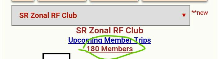
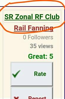
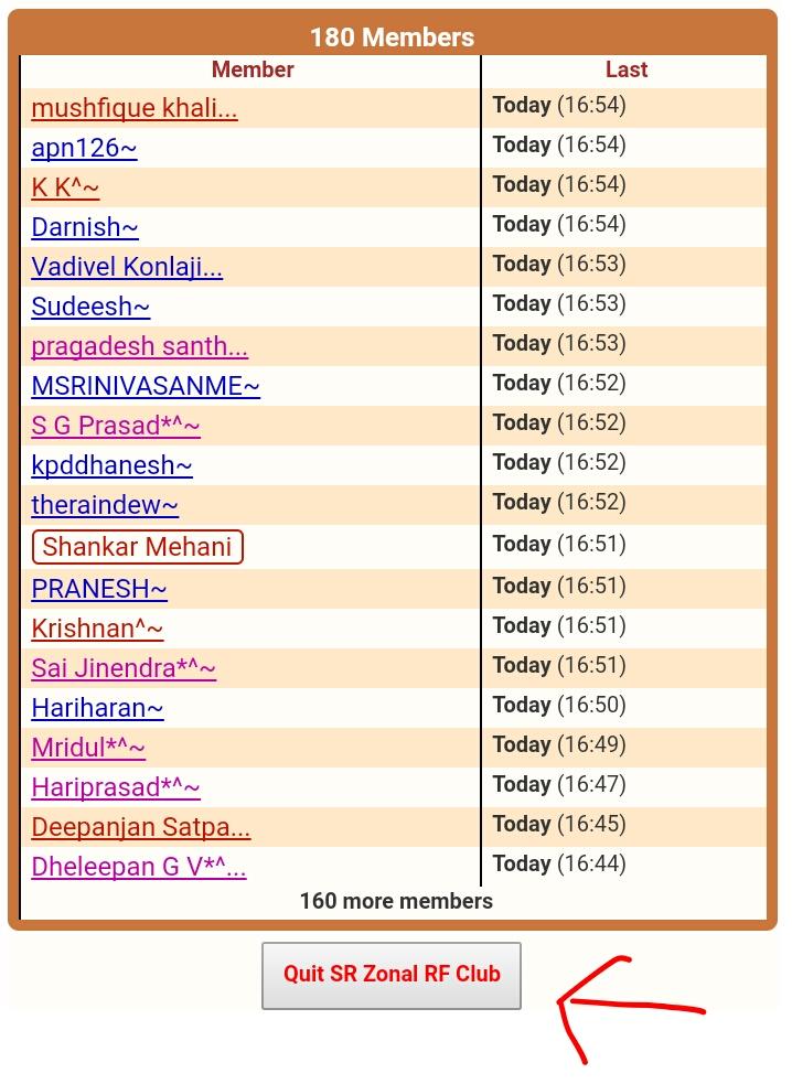
first go to RF CLUB Forum -- click on the link as shown in pic 1 (Note- you will find this on the left side of any RF blog) --
When you click the above link then again a page will be open consisting of all blog related to that RF club. On the top of page you will find as shown in pic 2, where you will Find all members of that group, click on the link of member-- after opening of page you will find "Quit From RF Club" as shown in pic 3, left side of the page .
.................
.so from following this simple step you will quit from any RF club if you want.
................
I hope you will understood.
.
A video is also added for mobile user
Video credit goes to Yashm
please wait...Translate to English
please wait...Translate to Hindi
#FAQ
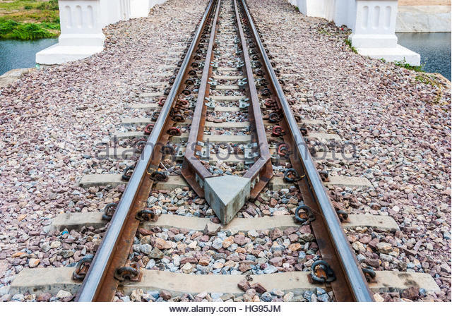
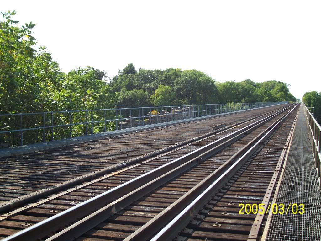
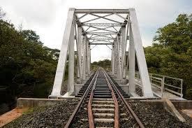
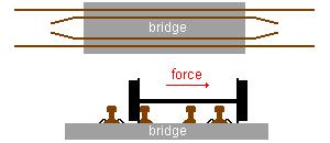
What guard rails and why are they used?
While traveling in a train you might have observed extra pair of rails are provided along a bridge, below a flyover or foot over bridge. These rails are known as guard rails. The purpose of the guard rails is to prevent the derailed train to hold on the tracks, not to moVe away from the track to avoid more destruction. The picture is self explanatory, that the guard rails hold the wheels of the bogies in case of a de-railment and prevent a...
more...
major catastrophe.
Just to prevent more destruction due de-railment. The bridges, flyovers may suffer a lot if de-railment occurs, but these rails prevent that from happening. Hope this clears all doubts regarding the side/guard rails.
Image courtesy--- Internet(google)
Just to prevent more destruction due de-railment. The bridges, flyovers may suffer a lot if de-railment occurs, but these rails prevent that from happening. Hope this clears all doubts regarding the side/guard rails.
Image courtesy--- Internet(google)
please wait...Translate to English
please wait...Translate to Hindi
Jan 04 2017 (04:40) 12431/Thiruvananthapuram Central - Hazrat Nizamuddin Rajdhani Express
TouristerDivyanshu^~
TouristerDivyanshu^~ 172567 blog postsEntry# 2115420 Tags Past Edits
Jun 07 2021 (12:12)
Train Tag: MGR Chennai Central - Hazrat Nizamuddin Garib Rath Special/06151 added by jigyasusingh47/2056059
Mar 03 2017 (12:55)
Longest 14715/6 Humsafar SGNR-TPJ = humsafar 12503/Bengaluru Cantt
- Kamakhya Humsafar Express with 3005 KM
Mar 03 2017 (12:54)
10
Longest Passenger = 54811/Bhopal - Jodhpur Passenger with 992 KM
11
Longest Humsafar = 12503/Bengaluru Cantt
- Kamakhya Humsafar Express with 3005 KM
12
Longest Antyodaya = 22877/Howrah - Ernakulam Antyodaya Express with 2285 KM
13
Longest MEMU = 63553/Asansol - Varanasi MEMU Passenger with 481 KM
14
Longest DEMU = 74835/Jodhpur - Hisar DEMU Passenger with 470 KM
15
Longest EMU = 64167/Palwal - Aligarh EMU with 188 KM
Jan 05 2017 (4:13PM)
Longest Super Fast=15901/KSR =22501/KSR Bengaluru - New Tinsukia Weekly SF Express with 3591 KM
Jan 05 2017 (6:26AM)
Longest Super Fast=12515/Thiruvananthapuram =15901/KSR Central Bengaluru - Guwahati New Tinsukia Weekly SF Express with 3554 3591 137
Jan 04 2017 (4:43AM)
Train Tag: Kanyakumari - Dibrugarh Vivek Express/15905 added by Technothlon 2017 with thinkDKG^~/1270085
Jan 04 2017 (4:43AM)
Train Tag: Thiruvananthapuram Central - Guwahati SF Express/12515 added by Technothlon 2017 with thinkDKG^~/1270085
Jan 04 2017 (4:43AM)
Train Tag: Visakhapatnam - Tirupati AC Double Decker Express/22707 added by Technothlon 2017 with thinkDKG^~/1270085
Jan 04 2017 (4:43AM)
Train Tag: Dadar - Madgaon Jan Shatabdi Express/12051 added by Technothlon 2017 with thinkDKG^~/1270085
Jan 04 2017 (4:43AM)
Train Tag: Kerala Sampark Kranti Express/12217 added by Technothlon 2017 with thinkDKG^~/1270085
Jan 04 2017 (4:43AM)
Train Tag: Chennai Central - Hazrat Nizamuddin Garib Rath Express/12611 added by Technothlon 2017 with thinkDKG^~/1270085
Jan 04 2017 (4:43AM)
Train Tag: Ernakulam - Hazrat Nizamuddin Duronto Express/12283 added by Technothlon 2017 with thinkDKG^~/1270085
Jan 04 2017 (4:43AM)
Train Tag: Bhopal Habibganj - New Delhi Shatabdi Express/12001 added by Technothlon 2017 with thinkDKG^~/1270085
Train Tag: MGR Chennai Central - Hazrat Nizamuddin Garib Rath Special/06151 added by jigyasusingh47/2056059
Mar 03 2017 (12:55)
Mar 03 2017 (12:54)
10
Longest Passenger = 54811/Bhopal - Jodhpur Passenger with 992 KM
11
Longest Humsafar = 12503/Bengaluru Cantt
- Kamakhya Humsafar Express with 3005 KM
12
Longest Antyodaya = 22877/Howrah - Ernakulam Antyodaya Express with 2285 KM
13
Longest MEMU = 63553/Asansol - Varanasi MEMU Passenger with 481 KM
14
Longest DEMU = 74835/Jodhpur - Hisar DEMU Passenger with 470 KM
15
Longest EMU = 64167/Palwal - Aligarh EMU with 188 KM
Jan 05 2017 (4:13PM)
Longest Super Fast
Jan 05 2017 (6:26AM)
Longest Super Fast
Jan 04 2017 (4:43AM)
Train Tag: Kanyakumari - Dibrugarh Vivek Express/15905 added by Technothlon 2017 with thinkDKG^~/1270085
Jan 04 2017 (4:43AM)
Train Tag: Thiruvananthapuram Central - Guwahati SF Express/12515 added by Technothlon 2017 with thinkDKG^~/1270085
Jan 04 2017 (4:43AM)
Train Tag: Visakhapatnam - Tirupati AC Double Decker Express/22707 added by Technothlon 2017 with thinkDKG^~/1270085
Jan 04 2017 (4:43AM)
Train Tag: Dadar - Madgaon Jan Shatabdi Express/12051 added by Technothlon 2017 with thinkDKG^~/1270085
Jan 04 2017 (4:43AM)
Train Tag: Kerala Sampark Kranti Express/12217 added by Technothlon 2017 with thinkDKG^~/1270085
Jan 04 2017 (4:43AM)
Train Tag: Chennai Central - Hazrat Nizamuddin Garib Rath Express/12611 added by Technothlon 2017 with thinkDKG^~/1270085
Jan 04 2017 (4:43AM)
Train Tag: Ernakulam - Hazrat Nizamuddin Duronto Express/12283 added by Technothlon 2017 with thinkDKG^~/1270085
Jan 04 2017 (4:43AM)
Train Tag: Bhopal Habibganj - New Delhi Shatabdi Express/12001 added by Technothlon 2017 with thinkDKG^~/1270085
*******LONGEST DISTANCES CATEGORY WISE TRAINS OF IR********
1. Longest Rajdhani =12431/Thiruvananthapuram Central - Hazrat Nizamuddin Rajdhani Express with 2845 KM
2. Longest Shatabdi =12001/Bhopal Habibganj - New Delhi Shatabdi Express with 709 KM
3. Longest Duronto =12283/Ernakulam - Hazrat Nizamuddin Duronto Express with 2638 KM
4....
more...
1. Longest Rajdhani =12431/Thiruvananthapuram Central - Hazrat Nizamuddin Rajdhani Express with 2845 KM
2. Longest Shatabdi =12001/Bhopal Habibganj - New Delhi Shatabdi Express with 709 KM
3. Longest Duronto =12283/Ernakulam - Hazrat Nizamuddin Duronto Express with 2638 KM
4....
more...
Longest Garib Rath =12611/Chennai Central - Hazrat Nizamuddin Garib Rath Express with 2175 KM
5. Longest Sampark Kranti =12217/Kerala Sampark Kranti Express with 3089 KM
6. Longest Jan Shatabdi =12051/Dadar - Madgaon Jan Shatabdi Express with 572 KM
7. Longest Double Decker =22707/Visakhapatnam - Tirupati AC Double Decker Express with 761 KM
8. Longest Super Fast =22501/KSR Bengaluru - New Tinsukia Weekly SF Express with 3591 KM
9. Longest Mail/Express =15905/Kanyakumari - Dibrugarh Vivek Express with 4234 KM
10. Longest Passenger = 54811/Bhopal - Jodhpur Passenger with 992 KM
11. 14715/6 SGNR-TPJ humsafar.
12. Longest Antyodaya = 22877/Howrah - Ernakulam Antyodaya Express with 2285 KM
13. Longest MEMU = 63553/Asansol - Varanasi MEMU Passenger with 481 KM
14. Longest DEMU = 74835/Jodhpur - Hisar DEMU Passenger with 470 KM
15. Longest EMU = 64167/Palwal - Aligarh EMU with 188 KM
#thinkDKG
please wait...Translate to English
please wait...Translate to Hindi
Travel SAFE
1. RailFanning does NOT MEAN dangerous pics/videos.
2. Doorplating pics/youtube videos are strictly FORBIDDEN in IRI.
3. Take plenty of food pics and other safe pics.
4. Write human interest narratives to make the pics interesting.
5. Enjoy blogging and travelling SAFELY.
REMEMBER: YOUR LIFE is the most precious thing, NOT RailFanning.
Leading Polls
| 4466128 ★★★ 105 | AvishekRay~ |
Top Trending Posts
| 6050597 ★ 7 | _V_K_^~ |
| 6039198 ★ 11 | AbDaali |
| 6029751 ★ 6 | hrid22~ |
| 6050553 ★ 6 | PrakharYadav^~ |
| 6048393 ★★★ 39 | WAP7NFRMLDT~ |
| 6030290 ★ 11 | K.K.^~ |
| 6050594 ★ 6 | SreenathSree^~ |
| 6048723 ★★★ 33 | MeghaSyam^~ |
| 5767634 ★ 11 | RohitBiharSharif~ |
| 5993434 ★ 10 | Manish_Arya^~ |
| 5616942 ★★ 14 | Manish_Arya^~ |
| 6046340 ★ 11 | Train.ka.diwana~ |
| 6046093 ★★★ 68 | MeghaSyam^~ |
| 6048340 ★ 6 | Train.ka.diwana~ |
| 5747807 ★ 6 | SreenathSree^~ |
| 6050503 ★ 9 | _V_K_^~ |
| 6050040 ★ 9 | Nischay_30479 |
| 6002421 ★ 8 | Snehashish_railfan... |
| 6044418 ★★★ 28 | Ehtram Husain~ |
| 6049473 ★★ 14 | GHAZIABAD_WAP7^~ |
| 6042420 ★★ 12 | sivaprakashofficia... |
| 6050339 ★ 6 | Abby_S~ |
| 6050180 ★★ 13 | _V_K_^~ |
| 6044701 ★ 6 | Pradeepkulkarni~ |
| 6049987 ★ 9 | SteelCityRF^~ |
| 6048662 ★★ 21 | WAP7NFRMLDT~ |
| 6012947 ★★★ 31 | MeghaSyam^~ |
| 6050029 ★★★ 25 | SHUBHAMNFR |
| 6017990 ★★ 15 | Snehashish_railfan... |
Rail News
- सरदानगर-खजनी तक बनेगा रेल बाईपास, सहजनवा-दोहरीघाट लाइन में मिलेगी
News Entry# 550678
by: Adittyaa Sharma Today (12:05)
गोरखपुर। आशीष श्रीवास्तव गोरखपुर जंक्शन पर ट्रेनों के बढ़ते दबाव को देखते हुए रेलवे...
गोरखपुर। आशीष श्रीवास्तवगोरखपुर जंक्शन पर ट्रेनों के बढ़ते... - स्काउट एंड गाइड के छात्र बुझा रहे ट्रेन यात्रियों की प्यास
News Entry# 550677
by: Adittyaa Sharma Today (12:00)
जमशेदपुर। रेलवे स्कूल स्काउट एंड गाइड से जुड़े छात्र टाटानगर समेत अन्य स्टेशनों पर जनरल बोगी के यात्रियों की प्यास ठंडा पानी देकर बुझा रहे...
जमशेदपुर।... - ट्रैकमैन को ड्यूटी में मिलेगा ओआरएस
News Entry# 550676
by: Adittyaa Sharma Today (12:00)
जमशेदपुर। टाटानगर समेत चक्रधरपुर मंडल के ट्रैकमैन को लाइल ड्यूटी के दौरान ओआरएस मिलेगा जबकि रनिंग कर्मचारियों को भी सुविधा...
जमशेदपुर। टाटानगर... - Summer Special Trains: गर्मी की छुट्टियों के बीच यात्रियों के लिए रेलवे ने लिया बड़ा फैसला, इन शहरों के लिए चलाई 48 स्पेशल ट्रेनें, देखें लिस्ट
News Entry# 550675
by: Adittyaa Sharma Today (11:58)
Summer Special Trains: स्कूलों की छुट्टियां शुरू होने के साथ ही लंबी दूरी की ज्यादातर एक्सप्रेस ट्रेनों में कन्फर्म टिकट के लिए मारामारी की स्थिति निर्मित होती है। इन दिनों तपतपाती गर्मी में इसका नजारा रायपुर समेत मंडल के सभी स्टेशनों में देखने को मिली रही है।
HighLights... - Joshi did nothing for K’taka despite being a minister: Moily
News Entry# 550674
by: Kalyan Els Has Wap7 Shortage Today (10:57)
TOI
...
New Trains
- Type: SFHWH/Howrah Junction to INDB/Indore Junction
Run Dates: Apr 28 to May 05
Runs: Sun
Dep: 10:00 Arr: 19:30 +1
Updated: Today (12:21) - Type: SFINDB/Indore Junction to HWH/Howrah Junction
Run Dates: Apr 26 to May 03
Runs: Fri
Dep: 22:30 Arr: 06:00 +2
Updated: Today (09:50) - Type: ExpMYS/Mysuru Junction (Mysore) to TLGP/Talguppa
Run Date: ONLY ON May 06
Runs: Mon
Dep: 21:30 Arr: 09:00 +1
Updated: Today (08:49) - Type: ExpRGS/Ringas Junction to RE/Rewari Junction
Run Dates: Apr 17 to May 26
Runs: Daily
Dep: 15:00 Arr: 18:20
Updated: Today (08:22) - Type: ExpRE/Rewari Junction to RGS/Ringas Junction
Run Dates: Apr 17 to May 26
Runs: Daily
Dep: 11:40 Arr: 14:40
Updated: Today (08:21) - Type: ExpBVC/Bhavnagar Terminus to HW/Haridwar
Run Date: ONLY ON May 01
Runs: Wed
Dep: 14:50 Arr: 19:00 +1
Updated: Today (08:14) - Type: ExpHW/Haridwar to BVC/Bhavnagar Terminus
Run Date: ONLY ON May 02
Runs: Thu
Dep: 22:00 Arr: 03:00 +2
Updated: Today (08:02) - Type: ExpYPR/Yesvantpur Junction to BIDR/Bidar
Run Date: ONLY ON May 06
Runs: Mon
Dep: 23:00 Arr: 12:00 +1
Updated: Today (00:43) - Type: ExpBGM/Belagavi (Belgaum) to MYS/Mysuru Junction (Mysore)
Run Date: ONLY ON May 06
Runs: Mon
Dep: 08:45 Arr: 20:15
Updated: Today (00:31) - Type: ExpBGM/Belagavi (Belgaum) to YPR/Yesvantpur Junction
Run Date: ONLY ON May 06
Runs: Mon
Dep: 08:00 Arr: 20:00
Updated: Today (00:12)
Site Announcements
- Entry# 5648027
Mar 01 2023 (12:44AM)
In response to past confusions with Train/Station updates and resulting fights and controversies, the following clear and objective guidelines are being issued, with no room for any arguments or debates about validity. Also, included, some other changes with respect to Ratings. 1. All Red Ratings will require further explanation. Red Ratings won't... - Entry# 5388512
Jun 24 2022 (08:45AM)
As announced previously, there are a few changes coming to IRI user accounts, based on past practices. 1. As before, you will be able to quickly DELETE your IRI User account at ANY time. However, the menu option for this was hidden in the profile page, and could not easily be located.... - Entry# 5148000
Nov 29 2021 (06:40AM)
A new feature will be released soon, whereby you can follow blogs tagged with specific Trains & Stations. If you have already posted blogs tagged with some Train/Station, then you will be set to automatically follow that Train/Station. Thereafter, any future news/blogs tagged with those Trains/Stations will be marked to your... - Entry# 5093784
Oct 13 2021 (07:04AM)
These days, every other day, we are getting requests from members to allow email login to their FB-based IRI account. 10 years ago, we had given the option for users to login through FaceBook - in retrospect, this was a mistake. These days, apparently, users are quitting FaceBook in droves because... - Entry# 4906979
Mar 14 2021 (01:12AM)
Followup to: Fmt Changes The new version of FmT 2.0 will soon be here - in about 2 weeks. As detailed in the previous announcement, many of the old FmT features like Train TT, Speedometer, Geo Location, etc. will be REMOVED. It will be a bare-bones simple app, focused on trip blogging. It... - Entry# 4898771
Mar 06 2021 (10:33PM)
There are some changes coming to FMT. Many of the features of FMT, like station arrival, TT, speed, geo, passing times, station time, etc. are ALREADY available in OTHER railway apps. So all of these features will be REMOVED. We'll have ONLY BLOGGING - quick upload of pics/videos/audio, etc. You may attach...
Member Blog Links
Scroll to Top